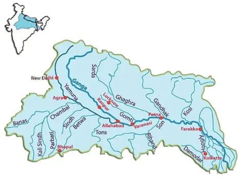
Ghagra River
Information

Its source is near Gurla Mandhata peak, south of Manasarovar in Tibet (river of the trans-Himalayan origin).
It is known as the Karnaili in Western Nepal.
After collecting the waters of its tributaries – Tila, Seti and Beri, it comes out of the mountain, cutting a deep gorge at Shishapani.
The total length of Ghaghara River up to its confluence with the Ganges at Revelganj in Bihar is 1,080 km.
The river Sarda (Kali or Kali Ganga) joins it in the plain before it finally meets the Ganga at Chhapra.
The Ghaghara joins the Ganga a few kilometres downstream of Chhapra in Bihar.
The river has a high flood frequency and has shifted its course several times.
Tributaries Koilar rivers, Khanua river, Khekhra Hirna, Jethan, Maun, Duhari, Kanch
#GhagraRiver #HimalayanOriginRiver
WEBSITE : https://geoias.com/
FACEBOOK : https://www.facebook.com/geoiaskolkata
INSTAGRAM : https://www.instagram.com/geoias
TWITTER : https://twitter.com/GeoIas
EMAIL ID : info@geoias.com
TELEGRAM : https://t.me/Geo_Ias
MOBILE APP : https://treeloki.page.link/Rg1u
YOUTUBE : https://www.youtube.com/@geoiasupsc
FORONLINE/OFFLINE CLASSES : +91 9477560001, 9477560002


